
Latest on the High Winds Today and Potential Winter Storm Friday into Saturday
Learn more about how your business can Sponsor the next Twin Cities weather update here: Advertise with Limitless Media!

TWIN CITIES, MINNESOTA: Twin Cities residents should prepare for strong winds today, followed by a potential winter storm late Friday night into Saturday. The National Weather Service has issued a Wind Advisory and a Winter Storm Watch for the region.
High Winds Expected Thursday
A Wind Advisory is in effect from 9 AM to 6 PM CST today for central, east central, south central, southeast, southwest, and west central Minnesota, as well as west central Wisconsin.
Winds: West at 25 to 30 mph, with gusts up to 50 mph.
Impacts: Unsecured objects may be blown around, tree limbs could be knocked down, and power outages are possible.
Precautionary Measures: Motorists, particularly those in high-profile vehicles, should exercise caution as strong winds can make driving hazardous.
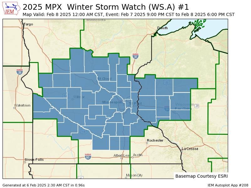
Winter Storm Watch Issued for Friday Night Through Saturday
The region may see significant snowfall as a Winter Storm Watch is in effect from late Friday night through Saturday afternoon. The affected areas include portions of central, east central, south central, and southeast Minnesota, along with northwest and west central Wisconsin.
Potential Snowfall: 5 to 8 inches.
Impacts: Road conditions could deteriorate rapidly, making travel hazardous.
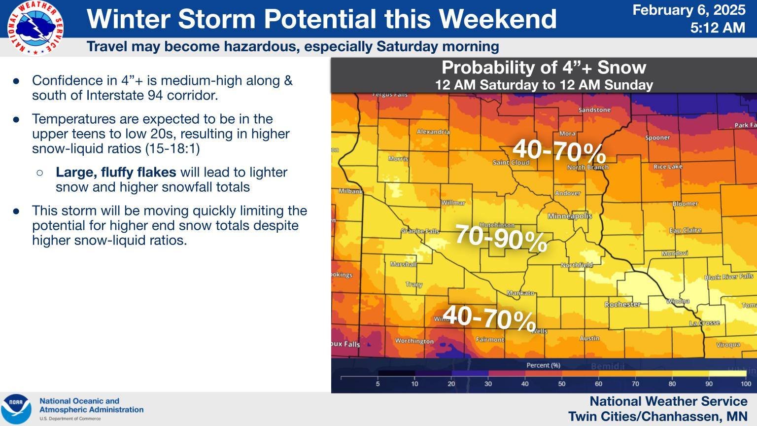
Storm Development: A low-pressure system forming near the Rockies is expected to move into the Ohio River Valley on Saturday, bringing moisture-rich air and strong mid-level forcing that will enhance snowfall rates.
Forecast Confidence: Based on the latest guidance, there is good confidence in snowfall amounts of 2 to 4 inches, with medium confidence in totals exceeding 6 inches. However, some model guidance suggests a possibly weaker and drier system, which could result in lower snow accumulations.
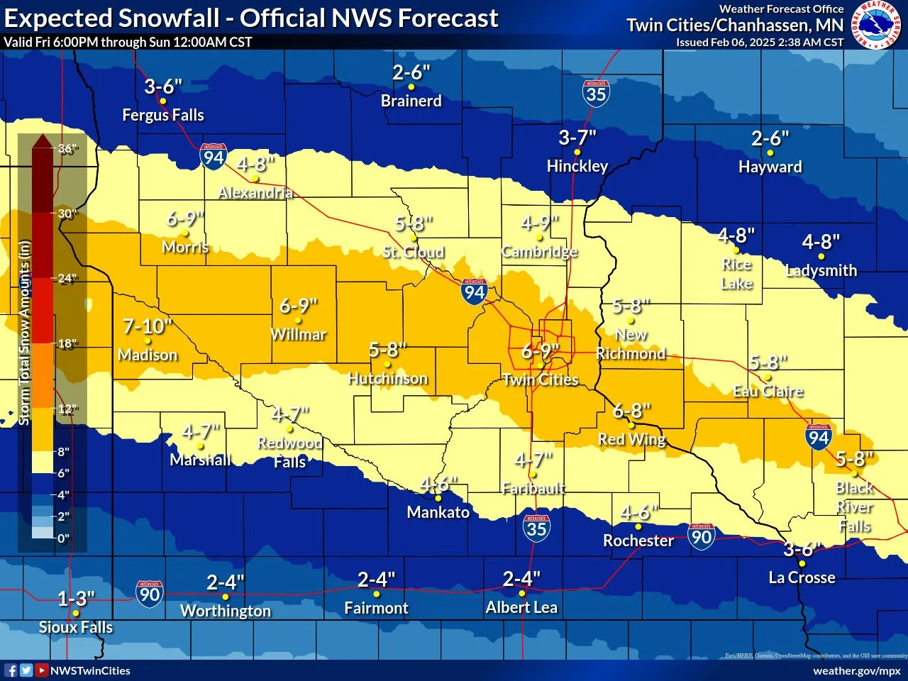
Latest Snowfall Forecast Totals from the NWS Twin Cities as of 2:38 AM on February 6, 2025
What to Expect
Forecast models indicate the heaviest snow could fall in a swath from Lac Qui Parle County through the Twin Cities Metro and into central Wisconsin. There is also a possibility of brief heavy snowfall at rates of 1 inch per hour on Saturday. Snowfall will taper off by Saturday afternoon in western Minnesota and by the evening in eastern Minnesota and western Wisconsin.
Stay Informed
Residents are advised to monitor weather updates and prepare for changing conditions. Travel may become difficult, and power outages remain a possibility due to both the wind and potential snow accumulations.
The above graphics were provided by the National Weather Service - Twin Cities.