
Severe Weather Outbreak Expected Monday Across Midwest and Upper Midwest: Strong Tornadoes Possible


TWIN CITIES, MINNESOTA - Residents across Minnesota are being urged to prepare for a severe weather outbreak on Monday, as the Storm Prediction Center (SPC) has increased the threat for the region to a Moderate Risk with the potential for strong to intense tornadoes, large hail, and damaging wind gusts.
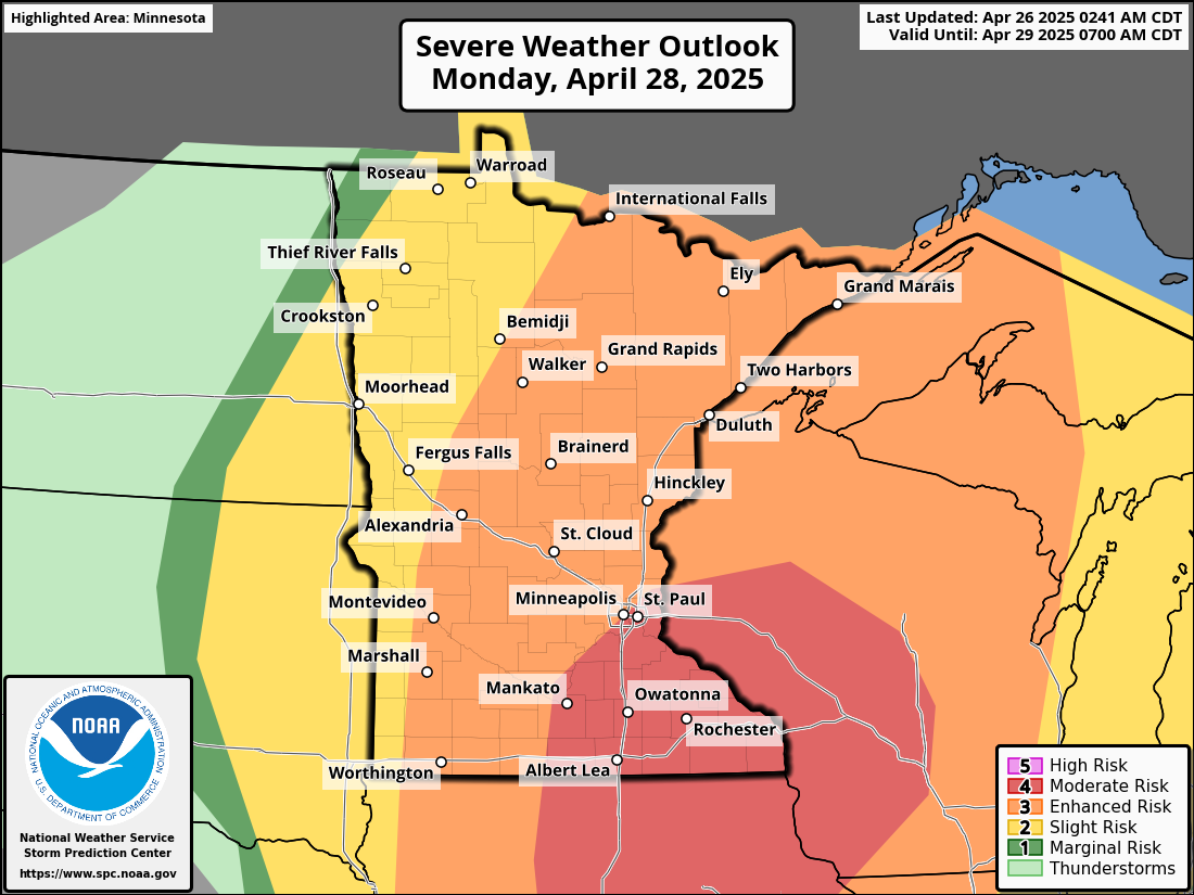
The Moderate Risk (level 4 out of 5) for severe weather stretches across a broad area from central Iowa into southeast Minnesota and western Wisconsin. A volatile combination of atmospheric ingredients will come together Monday afternoon and evening, making conditions unusually favorable for dangerous storms.
The latest model guidance shows an abundance of warm, moist air will be ushered northward across the region on Monday as a strengthening area of low pressure tracks into the region from the northern Plains towards the Great Lakes. Additionally, a strong mid-level jet streak, with winds between 70 and 80 knots, will race from the Southwest U.S. into the Upper Midwest. This setup is expected to generate a pristine warm sector with strong instability, setting the stage for the development of explosive thunderstorms.
Timeline of Events:
Sunday Night into Early Monday:
Thunderstorms are expected to develop late Sunday night into Monday morning across parts of southern Minnesota and surrounding areas. Some of these storms may be severe, primarily producing large hail and damaging wind gusts as elevated supercells are possible overnight.Monday Afternoon and Evening:
After a break Monday morning, the atmosphere will rapidly recover. Strong surface heating and high moisture levels will quickly help to prime the environment.
Initial thunderstorms are likely to develop by early afternoon along a cold front across western Minnesota. These storms could quickly evolve into semi-discrete supercells, capable of producing all severe hazards, including strong or intense tornadoes.Unlike many past severe weather events, mainly tied to a cold front (which often resulted in fast-moving lines of storms or QLCSs), Monday's system is expected to support a more scattered and discrete storm mode — a particularly concerning setup for tornado development.
As the day progresses, storms may congeal into a line (QLCS) as they move eastward, potentially producing additional damaging wind gusts and weaker tornadoes. However, areas that experience initial discrete supercells may be at risk for multiple rounds of severe weather.
Additionally, officials with the National Weather Service are emphasizing that this is not a typical severe weather setup for the region. Given the strength of the wind fields, intense instability, and the likelihood of supercells, there is significant potential for long-track, strong tornadoes in the area.
Safety Recommendations: Emergency officials are urging residents to review their severe weather safety plans now. People are encouraged to:
Have multiple ways to receive weather alerts (NOAA Weather Radio, mobile apps, etc.)
Identify a safe place to shelter (preferably a basement or interior room on the lowest floor)
Stay informed and continue to check back for the latest weather updates for Monday
Quick and decisive action will be necessary once warnings are issued, given the fast-moving and potentially violent nature of the storms on Monday.
Weather Radio Recommendation

We have provided a link to the Midland WR120B Weather Radio, currently available for $49.99 on Amazon with overnight delivery options. This is a model I personally own and have recommended to family and friends for many years. Please note that this is an affiliate link, meaning we may earn a small commission from purchases made through it; however, Midland is a trusted and reliable brand with a strong reputation in the weather community.
The WR120B is also widely available at local retailers, including Cabela’s, Bass Pro Shops, Walmart, Hy-Vee, Cub Foods, Ace Hardware, and Menards, if you would rather purchase it there. We don't care where you buy it, but we highly recommend having one and setting it up before Monday’s severe weather threat!
As a meteorologist, I strongly recommend that every home, business, and school have a reliable weather radio. Think of it as a smoke detector for severe weather. This critical tool can alert you to life-threatening storms, particularly during the overnight hours when other warning methods may fail. Weather radios have been proven to save lives and are an essential part of any severe weather safety plan.
You can also watch these old and awkward How To Videos for setting up this weather radio!