
Potentially Dangerous Severe Weather Threat Today for Minnesota
TWIN CITIES, MINNESOTA - Today is the day to be weather-aware as a potentially dangerous severe weather outbreak takes shape. Multiple rounds of storms are expected, with the most significant severe weather threat unfolding during the late afternoon and evening hours.
Morning Storms: Round 1
The first round of thunderstorms are working through the Twin Cities metro as we speak, and could potentially cause some minor issues for the morning commute. Pockets of heavy rain, small hail, and a few brief strong gusts will be possible from this activity, but this afternoon and evening will be the ones to watch.
Afternoon and Evening: Round 2 – Major Severe Threat
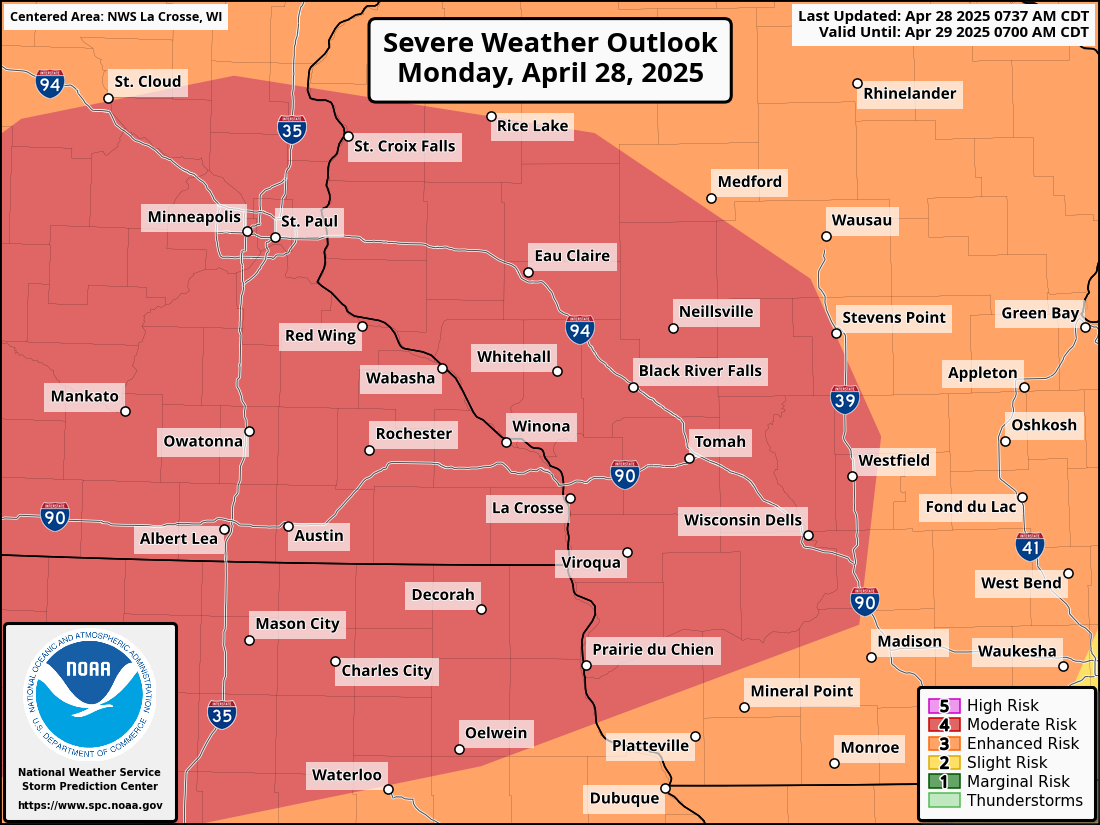
Following a brief lull in the action after the morning storms, the stage will be set for a much more serious round of severe weather this afternoon into tonight. This second round is the reason our region is featured in a Moderate Risk (Level 4 out of 5) issued by the Storm Prediction Center (SPC).
Key threats include:
Swaths of damaging winds (potential for widespread gusts over 60 mph)
Scattered very large hail (up to or greater than 2 inches in diameter)
Strong to intense tornadoes (potential for long-track tornadoes if discrete supercells develop) [more likely south of the Twin Cities Metro]
We will be keeping an eye on storm development along a dryline extending through southern Minnesota and northern Iowa during the late afternoon, around 1 to 3 PM, where these storms could initially form as discrete supercells capable of producing strong and long-track tornadoes.
Whether or not a “cap” can be overcome will be one of the key pieces that could cause these storms to organize and intensify quickly. Think of the cap as the lid on a soda bottle. If you shake the bottle and don’t open it, nothing happens. The moment you crack open that lid after shaking it, though, it begins to explode. That is precisely what could happen here today. If the cap can’t be broken, storms may wait to fire until the cold front sweeps through this evening, forming a line of storms (a squall line or QLCS), which would still pose a tornado threat but more likely produce damaging wind gusts and brief spin-up tornadoes.
The worst-case scenario would be discrete supercells developing ahead of the cold front, posing a significant risk for strong tornadoes and very large hail. The more common scenario may be a powerful squall line racing through the region during the evening hours, causing damaging winds and embedded tornadoes.
Why Today’s Setup is Dangerous
While the environment today will be highly favorable for severe storms, the situation is conditional, meaning it depends on whether storms can initiate ahead of the cold front. Can we get enough lift, or forcing to break the cap that we previously mentioned. The morning storms working through the region as we speak could help maintain a strong cap, preventing the early afternoon storms but enhancing the severe threat later by allowing instability to build throughout the day. If storms do initiate early, they could rapidly become severe, leaving little time for warnings.
Today is a day when you should stay vigilant and weather-aware, as there are multiple ways to receive warnings. Storms could rapidly intensify with little notice.
Timeline
Round 1 of storms is ongoing — isolated large hail, some strong storms during morning commute
9 AM–1 PM: Lull, atmospheric recharging, windy conditions
1–7 PM: Round 2 possible initiation — discrete supercells possible with strong tornadoes, large hail
7 PM–Midnight: Cold front moves in — line of severe storms, damaging winds, tornadoes still possible
After Midnight: Storms move into Wisconsin; risk tapers off
Bottom Line: Stay Alert Today
Severe storms are likely, especially late this afternoon and evening.
There is a risk for strong tornadoes, especially if discrete storms develop.
Have multiple ways to receive warnings (NOAA Weather Radio, wireless emergency alerts, local media, etc.).
Do not let your guard down between storm rounds. Conditions can change rapidly.
OUTDOOR TORNADO SIRENS ARE MEANT FOR OUTDOOR ALERTING! Don’t rely on that being your sole way to get tornado warnings or alerts!
DON’T TAKE COVER UNDER HIGHWAY OVERPASSES!
Stay safe and prepared today. Monitor trusted weather sources throughout the day for updates.